|
Dog Acre - well almost by Jennie Burgess Dog Acre was originally a strip of land now occupied by the western half of Alpha Road, with a small frontage butting onto Station Road. It belonged to the Church of All Saints and had been given to the Church by a local donor, probably in the 16th century. It was certainly a well-established piece of Church land by 622. During the Medieval and Tudor periods almost every householder owned a dog and there would always be a few stray ones around the villages and towns. If there was any trouble with the dogs fighting each other or attacking people, the local ‘Dog Whipper’ would be called to grab the offending animal around its neck with a large pair of wooden tongs, not unlike those that were used to lift washing from the boiler. Some communities still own their old wooden tongs. The Dog Whipper was paid,
sometimes in
cash, sometimes in kind and in Birchington's case, by the use of about
an acre
of land (or by a combination of these). He could cultivate this land,
or use it
for grazing an animal or even let it out to earn himself hard cash. The Dog Whipper first
appears in the Church
accounts in 1622: 1622 'Old Hayward'
was the Dog Whipper - plus 8s 1628 ‘Old
Posier’
took over the job until 1643 - still with the additional 8s. 1685 'John Taylor -
Dog Whipper -1 accer of land’. 1687 'John Taylor -
Dog Whipper, for his said office have 1 accer of
the said land.' 1694 'On accer now
lett out Thomas Pennev Dogg Whiper.
Abutting to the Butt Acer.' (The Butts
were where men of
the village practised archery every week in Medieval and early Tudor
times)
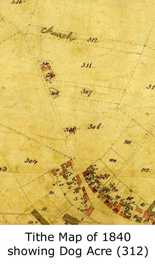
In the 1840 Tithe
Map, Dog Acre is
listed as
containing 3 rods 31 perches (i.e. only 9 perches short of an acre) The
land is
listed on the 1872 Ordnance Survey map as 'Dog Acre', plot 54. In about 1880, it was
decided to build the
first new road in Birchington, running parallel with the south side of
the
railway line. The
Church was asked to
sell the main part of this piece, leaving just the triangle near the
station in Church
hands. "Beaconsfield"
was, and for some
time remained, the only house in the road, which ran from Station Road
comer to
the top of Albion Road, then known as Wilson's Road or Coleman Stairs
Road. There is a photo of this
last triangle of land with fencing and gates on it, indicating that it
was
being used for grazing land at this date. In 1921 the Parish Council
asked for the
church to sell its last remaining corner, which it eventually did, once
the
Charity Commissioners had agreed, for £390. The proceeds were
invested in War
Stock, clearly documented in the Church accounts. In June 1975 Birchington
Residents'
Association won a fight to stop Thanet Planning Committee from granting
permission for the building of a new Post Office on the site. It is said to have been
purchased for
£74,000 (see above paragraph!) as an open space. A petition
containing 1,200
signatures was presented and the decision to reject the planning
request was
unanimous. In
November and December of
the same year a footpath was laid across Dog Acre. Birchington's
Chamber of
Commerce and Thanet Council shared the cost between them. Its latest
newsworthy
event is the addition of a new lamp, installed, but not yet functioning! |